You may remember Gordon Chaffin’s Street Justice newsletter, the free version of which we shared here in 2019 and early 2020. After the pandemic hit, Gordon restructured his newsletter’s model and has now created a new journalism portal. You can follow the new StreetJustice via their Linktr.ee. Below, an excerpt from their last SubStack newsletter. You can read more by clicking here.— María Helena Carey
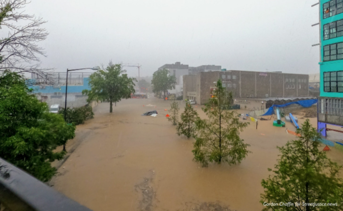
On Thursday, September 10, 2020, a severe rainstorm dropped three to six inches of rain on the Washington region, overwhelming brand new stormwater management infrastructure. Roads in the area flooded to depths greater than human height. Basements in the heaviest hit areas — DC’s Northeast quadrant and in Prince George’s County, Maryland — filled with stormwater and even sewage.
Last week, Street Justice spoke with several of the Washington region’s water experts. They told us that the DMV, and District government in particular, is investing significant amounts of money in water resiliency. Big stormwater diversion tunnels are being built underground, homeowner programs for green infrastructure are getting more generous, and new developments have stormwater management mandates. Arlington County is also investing huge capital budget money in water infrastructure where 2019 flooding occurred.
The experts told us that floods like the ones on September 10th will happen more frequently because of climate change — pushing out the frequency, intensity, and duration of storm events causing flooding. “The fact remains, we are probably going to see more storm events like [the kind of storm we had on September 10] because of climate change,” said Phillip Musegaas of the Potomac Riverkeeper Network. “It’s a challenge the city has to deal with going forward.”
Planning decisions in transportation, land-use, housing, and more which increase impervious surfaces — especially with greater road space — will make the impacts on climate greater and the flooding events much worse.
Lower-Income Neighborhoods in DC & Prince George’s County, MD Endure the Worst Flooding, Highlight Anacostia River Improvement Needs
The worst flooding in residential homes and local streets from September 10 occured in Northeast DC and the nearby Prince George’s towns of Mt. Rainier, Bladensburg, Colmar Manor, Cottage City, and Edmonston (collectively known as “the Port Towns”). Why were these relatively Blacker, higher-percentage working-class communities under greater threat? All of these areas are part of the Anacostia River watershed. A big factor in the flooding was how depleted the Anacostia is today after 200 years of negative effects from land use and development.
“Flooding is definitely anthropogenic,” said Trey Sherard, Interim Anacostia Riverkeeper. “Historically, the Anacostia River was literally twice as deep — 40 feet at its mouth — as it is now, only 20-25 feet.” Sherard went on to explain how the Bladensburg, MD waterfront was once one of the largest Transatlantic shipping ports. But European immigrants degraded the Anacostia in the 1700s and early 1800s with runoff and sediment from slash-and-burn agriculture upstream. Agricultural uses in the Anacostia watershed gave way to the development of suburbs in Prince George’s County.
“Suburban development started paving more things and that just exacerbates the problem,” said Sherard. “The development of the suburbs for cars was worse even [than the agriculture] and all those hard surfaces are impervious and [have] led to a ton more stormwater runoff because now the water can’t even get underground the way it used to.” Sherard explained that stormwater, especially at the sudden volume of September 10th, will find smaller, shallower streams — digging up sediment and pushing it downstream into the river. So even though ongoing projects are dredging and cleaning the upper Anacostia, the flow of channelized rainwater on hard surfaces can send even more new polluted sediment back into the river.
Sherard explained that many of today’s equity problems for residents near the Anacostia stem from both the historical harm and the continued environmental damage from land uses in areas with more affordable housing and greater minority populations. Today, the Anacostia River Sediment Project is working to dredge sediment with harmful chemicals from those historical uses and cap the bottom of the river so future disturbances won’t kick the toxins up where they could reach nearby residents. Those chemicals “are highly persistent; they’re carcinogenic. The PCBs, in particular, are developmental toxins, so they cause lifelong learning and behavioral disabilities.” Sherard explained that the chemicals come from old industrial users like the Navy, Pepco, Washington Gas, and agricultural runoff with pesticides.
While huge amounts of money can help in the form of building underground storm and wastewater management, excess water from storms like on September 10 will flow along roads that used to be creeks, such as North Capitol in Bloomingdale, DC. “The solution is to stop paving everything,” said Sherard. “In Maryland, for instance, the State Highway Administration is a disaster for stormwater. They are constantly looking for ways where they don’t need to be part of the solution. A huge proportion of our impervious area [is] roads, and that’s one of the biggest contributors to stormwater runoff. Every [bit of] oil, grease, piece of metal, piece of plastic, [or] piece of rubber that shakes, falls, burns, [or] drops off that car is washing into rivers the next time it rains.”
Keep reading the newsletter here.