As described last week, the house numbering scheme in Washington D.C. through the 1860s was a bit of a mess. And the post-Civil War period in Washington was about nothing if not cleaning up messes – often those created by the huge number of people who had moved to the nation’s capital during that struggle.
The earliest attempt I have found came in 1867, when a member of the Common Council named Connolly “submitted a resolution directing the Committee on Police to inquire into the expediency of reporting a bill authorizing the houses of the city to be renumbered,” as the Daily National Republican reported on June 25t of that year.
Three days later, a letter writer sent to the same newspaper a letter that he signed “Reformer,” in which he suggested that the “Philadelphia Plan,” in which each block contains room for 100 addresses, but that the streets be renumbered, starting with 1st Street next to the Potomac and then proceeding east ending with 57th street at the Anacostia.
While “Reformer” had indeed pointed out a flaw in the renumbering plan, his solution only addressed one of the problems, in that there still would have been two sets of lettered streets. Three months later, William H. Boyd, weighed in, repeating Reformer’s plan and adding that “the change would be be opposed by a few who have hoed their life on these old streets, but are we to go back to the old days of ploughing the ocean with sails when we can use steam.”
Two years later, finally, a bill was properly introduced. While the exact method laid out was not reported, that hardly mattered, as William H. Chase introduced a substitute bill that provided “for the adoption of the Philadelphia plan, the numbers commencing at north, south and west Capitol streets.” What happened to those streets beginning from East Capitol Street was not mentioned.
A few weeks later, the Washington Evening Star weighed in, describing the new system more thoroughly:
It would also be necessary, for a more particular indication of localities, to designate these four grand divisions or districts respectively as the North-Eastern, North-Western, South-Eastern and South-Western. Then, for example, what is now 320 K street north, between 13th and 14th streets west,” would simply be, say, 1324 K street N.W.;” and so on the same way for a given locality in either of the other divisions or districts.
This was hardly the final word, as further attempts to come up with another scheme – including having all numbers west and north begin at 1, and those starting east and south begin at 2,500. In the end, on November 29, 1869, a bill setting into law the quadrant system was approved.
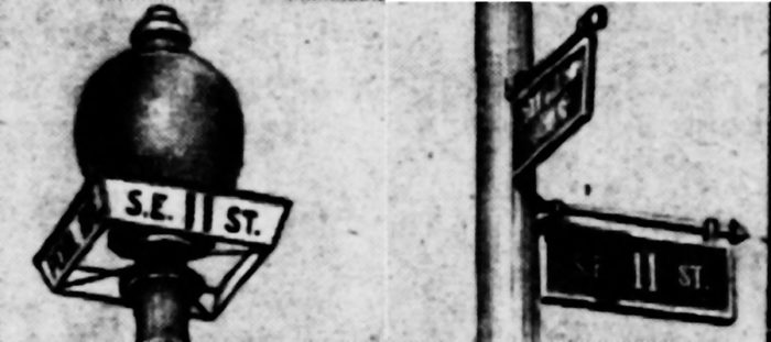
A little over a week later, Mayor Sayles Jenks Bowen (pictured above) awarded a contract to Samuel Strong to renumber the streets. The following day, Strong and his men were “already entered on the work,” which had each house receive a tin plate with numbers four inches wide and the “lamps on the corners […] designated by the letter and number of the street.”
The change came too late for the 1870 city directory. It would not be until the 1871 edition that diarist Michael Shiner’s address would finally be given under the new reckoning: “338 9th se”